
A River’s Tale: How a Reservoir and Human Activity Have Changed the Ravi

What does a healthy river look like? For most of us, an obvious answer would involve two aspects: water flowing through a channel and green vegetation along its banks. However, in reality, a river’s health depends on several factors, such as how much water flows through it, how water moves through the landscape, how that flow changes with the seasons, how sediment moves downstream, how often it spills into its floodplain, and how these processes change with the seasons.
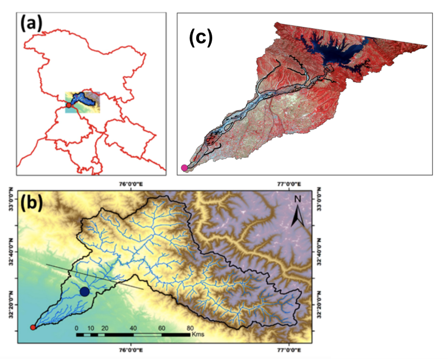
A new study involving researchers from the Indian Institute of Technology Gandhinagar (IITGN) examined such changes in India’s Ravi River downstream of the Ranjit Sagar (Thein) reservoir. By combining long-term discharge data with nearly three decades of satellite imagery, they traced modifications in river flow, surface-water extent, vegetation, and human activity across the floodplain. Published in Next Sustainability, the study underscores the need for sustainable management practices.
Reservoirs as Providers and Rhythm Changers
By storing and regulating water, reservoirs can help meet human needs such as irrigation, hydropower generation, and controlled water availability. Amongst the highest earth-fill dams in India, the Ranjit Sagar Dam, constructed on the Ravi at the border of the Union Territory, Jammu and Kashmir and the state of Punjab, serves these purposes.
Although reservoirs have their fair share of benefits, they can alter a river’s rhythm! Regulating a river can change the timing and magnitude of its natural high and low flows. Reservoirs can also trap sediment that would otherwise move downstream. With less sediment and a different flow regime, downstream channels can respond by eroding, narrowing, deepening or otherwise changing their shape.
According to Dr Indra Mani Tripathi, “In dryland regions, where water availability is already limited, communities and ecosystems may depend on seasonal flows. Even relatively small changes in water can have impacts on biodiversity, water availability, and ecosystem functioning in such systems.” The first author of this study, Dr Tripathi, is a Postdoctoral Research Associate and PhD alumnus in Earth Sciences from IITGN.
Redrawing the Landscape
The researchers compared conditions before and after the Ranjit Sagar reservoir began operating on the Ravi. They used daily river discharge data from 1980 to 2019. In simple terms, daily river discharge is the volume of water that flows through a specific point in the river over a 24-hour period. The team chose April and May (pre-monsoon months) to avoid additional release of water from the reservoir. They also analysed satellite imagery to track changes in water and vegetation across the floodplain. They found that median discharge fell from 296 cubic metres per second during 1980–2000 to 221 cubic metres per second during 2001–2019.
According to Professor Vikrant Jain, “A sustained change in flow impacts the river’s ability to transport sediment, which further leads to changes in river morphology and floodplain processes. Over time, such aspects can influence the connection between the river and its floodplain.” Prof Jain is a Professor in the Department of Earth Sciences at IITGN, where he also serves as the Head of the Department.
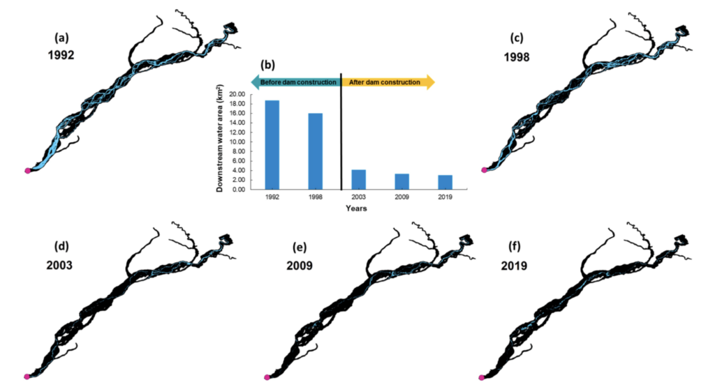
While satellite imagery from 1992 and 1998 showed a more prominent water network across the floodplain, these features became much less apparent following reservoir construction in the years 2003, 2009, and 2019. The estimated mean surface-water area fell from 17.35 square kilometres to 3.46 square kilometres, indicating a fivefold reduction in water availability. This reduction may have implications for areas like agriculture, although this impact was not directly assessed in the study.
Another finding was an increase in vegetation in parts of the floodplain where the active water area became smaller. “In a floodplain, periodic movement of water and sediment helps keep some areas dynamic. When these processes become less frequent, vegetation can establish more easily, potentially making some parts of the floodplain more stable and less connected to the active channel,” explained Professor Pranab Kumar Mohapatra, Department of Civil Engineering, IITGN.
A relatable example is that of a footpath through a field. When people stop walking on it, grasses and shrubs begin to grow. Then it becomes difficult to walk on it again.
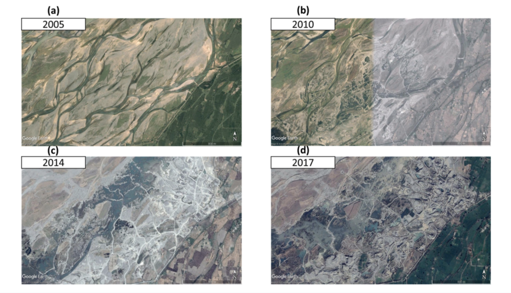
The researchers also looked at the impacts of sand mining and human activity on the river and its floodplain. Using high-resolution imagery (e.g., Google Earth), they identified features such as artificial pits and areas where the river pathway had changed. The changes were not uniform across the floodplain.
“Our study indicates that effective river management needs to consider several factors together. Changes in flow, sediment movement, land use, and sand extraction can build upon one another over time. Understanding these interactions gives us an opportunity to identify where interventions can help maintain a healthy balance between human use and river processes,” said Dr Ankit Modi, former Research Associate at IITGN and Assistant Professor in the Civil Engineering Department, Gujarat Technical University.
Such an approach is consistent with the Central Water Commission’s guidelines on maintaining longitudinal connectivity through dams, which address sediment and fish connectivity and discuss reservoir sediment-management strategies that can help reduce sediment-starvation effects downstream.
Looking Beyond the Ravi
Dr Shanti Shwarup Mahto expressed, “The Ravi is part of a much larger global story. Around the world, rivers are being modified by dams, sediment extraction, land-use change, and climate variability. Our study places the Ravi alongside examples from the Colorado, Mekong, Murray, and Yangtze, among others. The more information we have about how such factors interact, the better equipped we are to manage water infrastructure while preserving the river processes that support healthy floodplains and ecosystems.” Dr Mahto is a PhD alumnus in Earth Sciences from IITGN and an Assistant Professor at the Central University of Jharkhand.
The findings of this study align with India’s National Water Mission, whose stated objective includes conserving water, reducing wastage and ensuring equitable distribution through integrated water-resources development and management. Globally, the study is in alignment with aspects of the UN Sustainable Development Goal 6, focused on sustainable management of water and integrated water resources, as well as the restoration of water-related ecosystems such as rivers and wetlands.
Other team members involved in this research included Dr Aamer Majid Bhat (Postdoctoral Research Associate) and Bhanu Parmar (Junior Research Fellow) at the Department of Civil Engineering, IITGN. The researchers acknowledge financial assistance from the Ministry of Education, Ministry of Science and Technology, and Ministry of Earth Sciences, Government of India.